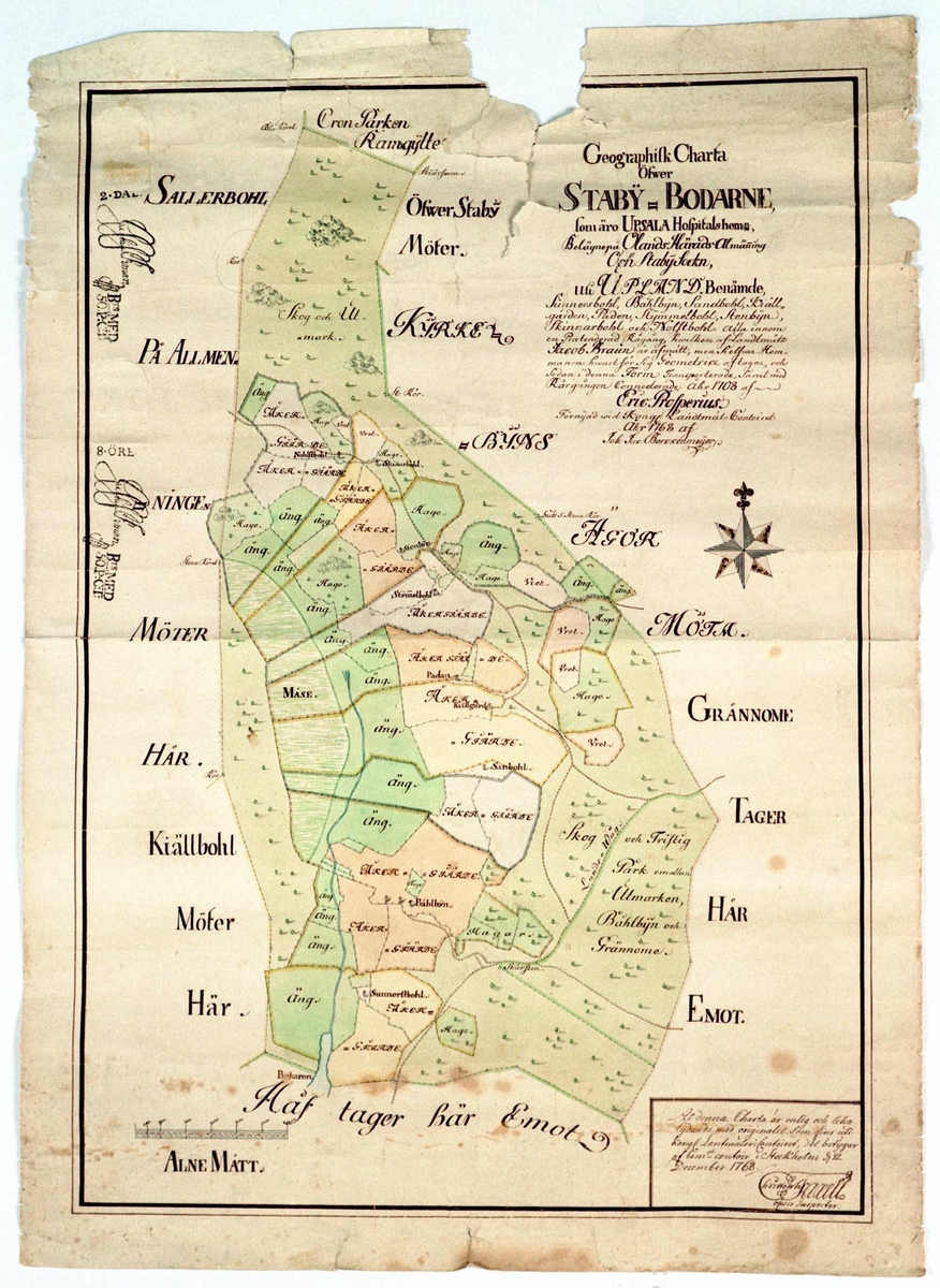
Photo: Upplandsmuseet Accept license and download photo Karta icon--add Add to folder icon--add Add to folder Remove from folder Order image 0 Comment/inquiry social--facebook social--more Share About the object aboutGeografisk karta. Kolorerad. Visar Staby-Bodarne, Uppsala hospitals hemman, Olands härad, Staby (Stavby) socken, Uppland. Datering 1708/1768. DesignationKarta IdentifierUMAKU08 Avbildad, ortSverige Uppland Uppsala Uppsala Stavby Stavby bysäker Indexing termKartor Specific subject termsBeskattning Skrift Karta Type Thing Created with Sketch. Add a comment or suggest edits History Geografisk karta över Staby-Bodarne, Uppsala hospitals hemman, Olands härad, Staby socken, Uppland. (Troligen Stavby). Originalet tillverkat 1708 av Eric Prosperius. 1768 förnyad vid Kungliga Lantmäterikontoret.Produktion: 1708 Tillverkare av originalProsperius, Ericsäker Created with Sketch. Add a comment or suggest edits Classification Kartor (Outline)OU 102 Motif classification Geografisk belägenhet, samt kartor (Outline)OU 131Markanvändning (Outline)OU 311Skattesystem och statsinkomster (Outline)OU 651 License information License CC CC0 1.0 Metadata IdentifierUMAKU08 Part of collectionUpplandsmuseets samlingar Owner of collectionUpplandsmuseet InstitutionUpplandsmuseet Date publishedFebruary 3, 2023 Date updatedFebruary 3, 2023 DIMU-CODE0210213240485 UUIDadb44797-72c6-475b-a710-c0f50d3effee Tags For adding tags, log in. There are 74 results for «Kartor» in Upplandsmuseet: Karta. Handmålad karta i akvarell och tusch på papper, i svart tr... Karta. Tryckt. Vaxad duk. Visar landsvägarna i Sverige och Norge ... Karta. Tryckt. Karta över Norden från 1820. Kartan innehåller mån... Karta. Visar Danmark. Rutnät. Inga orter eller annat utmärkt. Str... Karta. Tryckt. Kolorerad. Visar storfurstendömet Finland. 1799. U... View more Add a comment or suggest edits To publish a public comment on the object, select «Leave a comment». To send an inquiry directly to the museum, select «Send an inquiry». Leave a comment or send an inquiry You are not logged in – Log in You are not logged in – Log in Your name Your email Add comment or cancel Send an inquiry Your message will be sent to Upplandsmuseet. Recipient Message You are not logged in – Log in Your name Your email Send email or cancel New comment or inquiry


Add a comment or suggest edits
To publish a public comment on the object, select «Leave a comment». To send an inquiry directly to the museum, select «Send an inquiry».